
Cascades Circuit
Scenic Rim
Main Range National Park (Goomburra)


A feature-packed walk through varying forest types, featuring an impressive waterfall, numerous cascades, rocky overhangs and creek crossings.
This moderately trafficked, well-marked trail in the Goomburra Section of Main Range National Park starts at the Manna Gum Camping Area at the end of Forestry Reserve Road.
The circuit begins on a wide and well-maintained fire trail through open eucalypt forest, climbing steadily for approximately two kilometres to the Spicers Retreat for Scenic Rim Trail walkers.
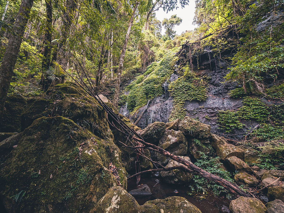
There is then a dramatic change in vegetation, as you enter lush rainforest and the path narrows as you descend to the upper reaches of Dalrymple Creek.
The circuit then follows the creek, crossing it several times and passing countless cascades. A standout feature of the walk is Cascade Falls, where the water rushes through a series of deep pools before tumbling over the edge of a large rock face and cascading through foliage to the pools below.
There are a number of instances in which you might feel that you won’t get optimal views of the cascades or falls, including Cascade Falls, however the track often passes these and then a short side-track cuts back to an optimal vantage point.
At one of the creek crossings, it is worth exploring the rocky overhang about 30 m downstream (clearly visible from the creek crossing).
There are also numerous spots along the latter section of the track where small pools beckon a quick dip to cool down in warmer months.
This circuit can also be easily combined with the Dalrymple Circuit, without adding any additional distance, by taking the right branch at the signed junction.
Track: Graded and well-signed, the track is easy to follow. The ascent is primarily along wide and well-maintained fire trails, while the descent is through the rainforest along steep paths, switchbacks and steps. The latter section of the walk is somewhat undulating.
Difficulty: The track has a number to steep sections, some of which could be slippery when wet. The circuit requires a moderate level of fitness. Care should be taken at creek crossings as the rocks can be slippery, especially after rain.
Direction: The track can be completed in either direction. This choice largely depends on your preference for the elevation profile.
Anticlockwise involves approximately two kilometres of steady ascent (average 10% grade) up a fire trail, with the descent through the rainforest on more narrow paths. This direction is recommended for people with joint issues or who are not as steady on their feet.
Clockwise involves a somewhat more gradual ascent through the rainforest (which would be slippery when wet), followed by a descent along the fire trail.
getting there
The trail starts from the Manna Gum Camping Area at the end of Forestry Reserve Road in Goomburra, 2.5 hours drive south-west of Brisbane.
The car park is small but there is additional parking a short walk away at Poplar Flat Camping Area.
best time to go
The walk can be completed year-round.
This walk is best done after recent rain, in order to see water flowing through the cascades, however is pleasant at any time. If completing after recent rain, be sure to check the Queensland Parks website for updates regarding flooding and track closures.
Remember, whenever venturing into the outdoors, practice the Leave No Trace principles and be considerate of others. This means: dispose of your waste properly, don't remove things or move things from their natural position and respect all wildlife. Also be sure to plan ahead and adequately prepare for any adventure.
I respectfully acknowledge the Traditional Owners of the land on which all activities listed on this website are found, as well as Elders past, present and emerging. I strive to not promote sites where requests have been made for people not to explore due to the cultural significance of the site to Indigenous peoples, or note how to respectfully visit a site. If I have a promoted a site with cultural significance, please send me a message and let me know.