
White Rock Trail
Ipswich
White Rock - Spring Mountain Conservation Estate


A great walk through scenic bushland, along a ridgeline with city views, to an amazing rock formation with cultural significance.
This moderately trafficked hike starts from the car park at the Paperbark Flats Picnic Area near Ipswich.
The walk begins along a well-maintained fire trail. After roughly one kilometre there are two options for continuing to White Rock.
The Multi-User Trail is the easier of the two options, continuing along the fire trail to White Rock, through open eucalypt forest and paperbark trees, however offers very little in terms of views.
The more adventurous should tackle the Ridge Trail, which diverts from the fire trail and ascends through open forest, up rocky steps and slab sections to the ridge, which offers views to Brisbane City, the surrounding forest and housing developments, as well as a nearby weather station. There is also a small cave near a section requiring some light, unexposed rock scrambling.
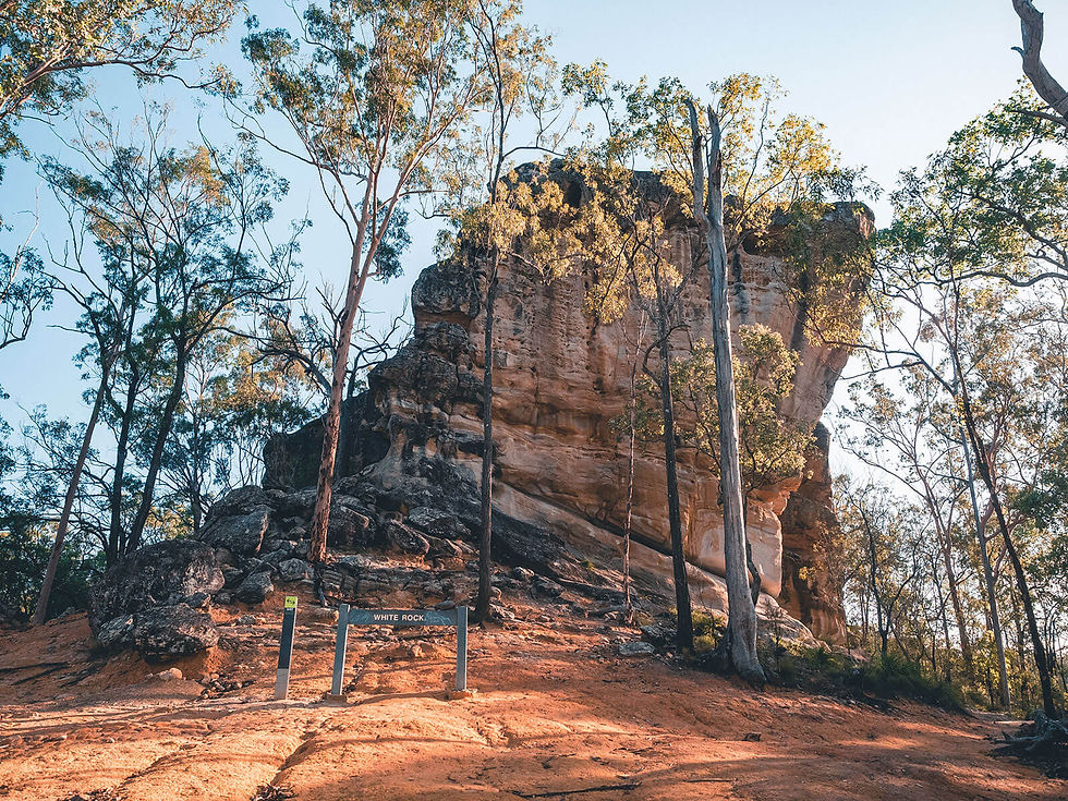
Once at White Rock, there are fantastic views of the rock formation, with its weathered faces and caves and overhangs. Out of respect for local Indigenous requests, do not climb to the top of White Rock. Excellent views are available from the rocky slab lookout on the Ridge Trail.
There is a track that circumnavigates White Rock, with the initial section offering excellent views of rocky overhangs. Either continue around the rock and reconnect with the Multi-User Trail to return to the starting point, or retrace your steps back along either the Multi-User Trail or Ridge Trail.
As stated, some of the landscapes within this estate, including White Rock, the caves and outcrop overhangs, are sacred sites that are very important to the Traditional Owners as they provide a link between Country and personal identity and allow the passing on of cultural knowledge.
As per Cultural Protocol the Traditional Owners have requested no one climbs White Rock.
There is also an option to add a combination of short circuits near the beginning of the track, without adding much distance.
Track: Both the Multi-User Trail and Ridge Trail are graded and easy to follow. The Multi-User Trail is a well-maintained fire trail with some steps just prior to White Rock. The Ridge Trail involves some sections of rocky steps and a short and unexposed rock scramble after the slab lookout.
Difficulty: The Multi-User Trail, while steep in sections, is suitable for all fitness levels. The Ridge Trail requires a little more fitness and the track is rougher, with a small section of unexposed rock scrambling required. The Ridge Trail also has some exposed cliffs near the track, so care must be taken when close to the edge.
Direction: The track can be performed as either an out-an-back track that returns the way it came, or as a circuit. If completing as a circuit, it is recommended to complete the walk clockwise (ascend via the Ridge Trail and descend via the Multi-User Trail) at sunset or anticlockwise (ascend via the Multi-User Trail and descend via the Ridge Trail) at sunrise.
getting there
The trail starts from the car park at the Paperbark Flats Picnic Area near Ipswich, 45 minutes drive south-west of Brisbane.
The car park is ample, however can become busy on weekends and some afternoons.
Be advised the carpark is closed overnight – be sure to check the times on the sign and time your walk accordingly. There is an option to park outside the main parking area and walk a couple hundred metres to the trailhead if wishing to complete the walk at sunrise or sunset.
best time to go
The walk can be completed year-round, however is somewhat exposed to the sun, so may be less enjoyable during the warmer months.
Check the Ipswich City Council website for updates on track closures.
Remember, whenever venturing into the outdoors, practice the Leave No Trace principles and be considerate of others. This means: dispose of your waste properly, don't remove things or move things from their natural position and respect all wildlife. Also be sure to plan ahead and adequately prepare for any adventure.
I respectfully acknowledge the Traditional Owners of the land on which all activities listed on this website are found, as well as Elders past, present and emerging. I strive to not promote sites where requests have been made for people not to explore due to the cultural significance of the site to Indigenous peoples, or note how to respectfully visit a site. If I have a promoted a site with cultural significance, please send me a message and let me know.